Old Harbour Bypass
Sections of the Bushy Park
Aqueduct
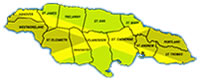
Parish: St. Catherine
Archaeological Impact Assessment Project (AIA)
The Government of Jamaica commissioned the Old Harbour Bypass as a part of its road improvement programme. The project falls within the portfolio of the Ministry of Transport and Works. The 14.7 Kilometers of highway will traverse the parishes of Clarendon and St. Catherine. The town of Old Harbour in St Catherine will be by-passed. Areas affected by the project include Nightingale Grove, Cherry Garden, Bushy Park, Gordon Wood, Church Pen, Old Harbour, The Whim, Bodles, in St. Catherine. While in the Parish of Clarendon, Freetown, Toby Abbott, Inverness and Sandy Bay will be affected. The Highway will run parallel to the railway line from Cherry Garden to Bodles in St. Catherine.
Sites which maybe affected by the Old Harbour By-pass Project includes:
- BUSHY PARK AQUEDUCT
- TOBY ABBOT
- INVERNESS
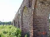
BUSHY PARK AQUEDUCT, St. Catherine
Cultural Context: Anglo-Jamaican
Date: c. Late 18th Century
The existing portion of the Bushy Park Aqueduct begins at the intersection at Gutters (South St. Catherine). It is situated approximately 35 metres east of Bushy Park Road runs parallel to as far as the railway crossing. It continues further south beyond the train line for about one hundred metres.
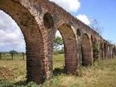 This unique aqueduct was built between 1760 and 1780 on the flood plains of Coleburns Gully. The alluvial sediments made the area ideal for large-scale cultivation of sugarcane. Today, the area is void of large scale cultivated crops. Vegetation cover is predominated by guinea grass and other varieties of grass, an indication that the area had been utilized as a grazing pen. Few acacia, mangoes and guango tress punctuate the area. However, the few houses that occupy portions of the land have a variety of fruit trees on their properties.
The aqueduct is currently in a good condition. However, areas around the aqueduct need to be cleared of vegetation.
Developmental Impact
The proposed highway construction may require the destruction of a significant portion of the aqueduct on the southern side of the train line. Approximately, 40 feet are projected to be destroyed. Already, about 25 metres have been demolished for construction of the railway track and parochial road.
The Field Team of the Archaeology Division is currently surveying, illustrating, photographing, and excavating the aqueduct in order to get the complete measurement of the structure.
TOBY ABBOT, St. Catherine
Cultural Context: Amerindian
Date Range: c.650-1500AD
Toby Abott is one of the sites, which will be destroyed as a result of the Old Harbour Bypass. Toby Abbott is located between the districts of Freetown and Inverness in the parish of Clarendon. The area proposed for the construction of the Bypass is relatively flat for the most part with limestone hills to the west. The Archaeology Division's archives had identified a Taino site in the area. During the plantation era Toby Abbot was a cattle estate.
The first field survey found wine bottle sherds around a dry pond area. A Taino site was also discovered nearby. This area has been excavated. Artifacts found revealed that the site should be classified as a redware transition site.
Developmental Impact
The highway construction may destroy portions of Taino sites not readily detected on the surface due to vegetation cover, namely Seymour grass.
Mitigation Action of the Archaeology Division
- A second field survey when the vegetation cover is removed.
- Watching brief during actual road construction.
INVERNESS, Clarendon
Cultural Context: Amerdian
Date Range: c.650-1500 AD
Inverness is located south of Sandy Bay, and the railway track. The topography is a combination of rugged limestone formation and large pockets of flat lands. Limestone hills are occupied by dense semi-arid shrub vegetation, while the low-lying areas are dominated by Seymour grass and small/acacia trees. The dense shrub overgrowth combined with rugged terrain made surveying efforts extremely difficult at times.
Archival documents have shown a large Taino site south of the proposed highway. A cordage factory is also located in the area. The team is aware of other structures that may possibly be linked to slavery.
Developmental Impact
The Taino site is not affected. Highway construction may destroy sites not yet discovered.
Archaeology Division's Mitigation Action
- Additional field surveys after the area has been cleared of vegetation cover
- Watching brief
- Pre-construction archaeological excavation if necessary
SHOWCASE
|
SHOWCASE
|
SHOWCASE
|