Woodside
Parish: St. Mary
The community of Woodside is one of the Jamaican villages replete with history. It has connection to the Taíno, the plantation era and emancipation. There is evidence of Taíno presence in the area in the form of a prehistoric petroglyph or rock carving site referred to as Dryland, Dry Grounds, Image Cave or “One/Long Bubby Susan”. This petroglyph site was first recorded in 1820 and later published by J.E. Duerden in 1897. As such it is the oldest known petroglyph site on the island. It is located in that part of Woodside called Rock Spring where there is a cave containing this petroglyph. Like many other indigenous groups, the Taíno used pictographs (rock paintings) and petroglyphs (rock carvings) to communicate and to document aspects of their lives. All of the pictographs and petroglyphs discovered in Jamaica have been found in caves. To date the Jamaican Taíno only chose caves or nearby boulders to produce petroglyphs and pictographs (Atkinson 2009, p. 47). This is what makes Jamaica unique in comparison with other Caribbean sites.
By 1812, the property continued to have the heirs of John Neilson listed as the owners, in particular, Dr. William John Neilson. Dr. Neilson had inherited the property from his father, who had died when William John was about ten years old. According to Dr. Erna Brodber, by an official document signed between John Neilson’s widow, Frances Maidstone and a William Neilson, it was agreed that William Neilson would manage John Neilson’s property until William John attained majority. Frances Maidstone went to England and took her son with her (Brodber, 1999). However, by 1811, William John’s name appeared in government records as a member of the judiciary and of the militia for the parish of St. Mary. Apparently, William John had attained majority by then and had returned to Jamaica to take charge of his inheritance.
The community also has other sites of interest including the former great house which was converted into a school. It is believed that in 1881 Jane Eliza gave her house officially to the Anglicans who made it a school. Dr. Brodber stated that from the church records, one will find that the community’s use of the school had been from 1893, if not before (Brodber, 1999). The school is no longer at this location and the site is now an old Anglican church, The St. Gabriel Anglican Church. There is also another vestige of Taíno presence in the area in some stone steps etched on a slope near the Anglican Church. These are known as Arawaks steps because according to the community folklore they were built by the Arawaks (Taínos). This would suggest the presence of the Taínos in the area. Dr. Brodber also highlighted that the site of the Anglican Church was believed to be a Taíno midden (Personal communication, 2014).
Additionally, there is a place called ‘Daddy Rock’, a cavern-like formation, where it is said the enslaved Africans would meet to socialize and discuss issues. This site has remained a part of the community’s social consciousness and is considered a place of reverence. The Emancipation observance, which takes place in Woodside on July 31 and August 1, ends at Daddy Rock. According to Dr. Brodber, “we transport ourselves back to 1838 and we go there to talk our own business. A re-enactment of the proclamation of the emancipation of the enslaved Africans is part of the observance” (Williams, 2013). Some families have already mounted plaques there with the names of their ancestors who worked on the Woodside plantation based on the entries in the Slave Returns for 1817. (Ibid).
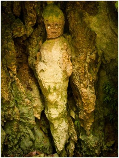 Dryland or “One/Long Bubby Susan”
The cave system known as Dryland is described as “a complex cave containing interconnected shafts, passages and chambers” (Fincham 1997, p.161). Fincham adds that it has a depth of 30 metres and a length of 125 metres (Ibid). It is located in a depression to the north of Dog Hole.
This cave contains a single anthropomorphic Taíno petroglyph referred to as “One/Long Bubby Susan” (Fincham 1997, p. 161). “One Bubby Susan” is a representation of the Taíno Earth Mother, Atabey, the mother of their supreme male deity Yocahu. The Taíno petroglyph at Rock Spring, St. Mary provides an interesting example of how Taíno material culture has been incorporated into Jamaican folklore (Atkinson, personal communication, 2014).
The petroglyph is called “One Bubby Susan”, as she has only one breast. It is derived from the African folklore of Long/Lang Bubby Susan, who is regarded as a duppy that terrorizes children, identifiable as the “Old Hige/Hag” (Atkinson, 2010).
This rock art site is also special to Akan, Yoruba and Dagara priests and priestess who treat the image and the cave as a shrine (Erna Brodber, personal communication, 2010). This veneration for indigenous rock art sites is not unique to Jamaica, as in Haiti, these sites are perceived as a source of healing, and incorporated into pilgrimages that take place in the summer (Beauvoir-Dominique, 2009, pp. 85-86).
St. Gabriel’s Anglican Church (Old Anglican Church)
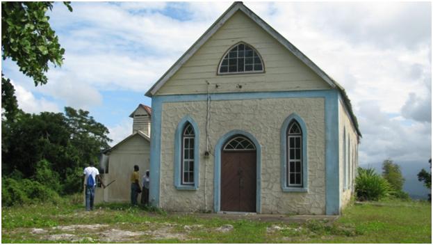
St. Gabriel’s Anglican Church
The church is of Georgian architecture built with cut stone and wood with quoins at the front and side of the building. The building has been altered with the construction of smaller adjoining structure to the left. The method of construction is generally in keeping with the period in which it was built, 19th century. We were unable to determine who built the church, however it has an attractive design. The interior is enhanced by a beautiful marble baptismal font at the entrance.
“Arawak” (Taíno) Steps
These are a set of fourteen steps located near the St. Gabriel’s Anglican Church which is believed to be the former Plantation House of the coffee plantation. According to folklore these steps (stone steps) were created by the Taíno who were the earliest settlers in the area (Woodside). These steps lead from the plantation house to the plains below. It is one of the sites visited during Woodside Community Emancipation celebrations each year. The Arawak steps are located in close proximity to a possible Taíno midden which located on the site of the St. Gabriel Anglican Church.
Daddy Rock
Daddy Rock is a cavern-like formation located in close proximity to the Anglican Church. According to Dr. Brodber, Daddy Rock is a religious and mystical space where former enslaved Africans would go to plan strategy for escape from enslavement. It was also a place of worship and solace. The name Daddy Rock suggests a father giving loving care to his children. Daddy Rock is final stop of the yearly Emancipation activities of the Woodside Community. Dr, Brodber adds that each year of the celebrations ‘we transport ourselves back to 1938, and we go there to talk our own business.
Sources:
- Brodber, E. 2004. Woodside, Pear Tree Grove P. O. (Kingston: University of the West Indies Press).
- Brodber, E.1999. The People of My Jamaican Village. (Kingston: The University Printers, UWI Mona).
- Fincham, A. 1997. Jamaica Underground. The Caves, Sinkholes and Underground Rivers of the Island.
- (Kingston: University of the West Indies Press)
- Higman, B. 1988. Jamaica Surveyed: Plantations maps and plans on the eighteenth and nineteenth centuries. (Kingston: Institute of Jamaica Publications Ltd.)
- IandIyanola. 2012. Establishing Blackspace: Emancipation in Woodside St. Mary (JA) retrieved from
- http://iandiyanola.wordpress.com/2012/08/27/establishing-blackspace-emancipation-in-woodside-st-marysja/ August 27, 2012
- Register of Slave Returns (St. Mary), June 28, 1817
- The Gleaner, Saturday, August 24, 2013: Woodside wants official heritage designation
SHOWCASE
|
SHOWCASE
|
SHOWCASE
|